- Reviews
- Usage example
- Description
- How To Edit
Slides
Reviews
Usage example
Description
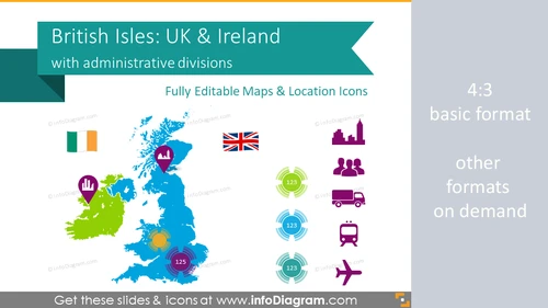
Editable PowerPoint maps of Great Britain and Ireland, the main two British Isles. The UK and Irish maps include outlines of administrative divisions - four UK countries (England, Scotland, Wales, and Northern Ireland) and their counties. We added icon sets for presenting the location of main cities, company offices, and headquarters, sales meeting plans, or regional points of interest. This PowerPoint template contains text placeholders and call-out boxes with basic economic data of Britain and Ireland. You are free to modify it and add your own descriptions.
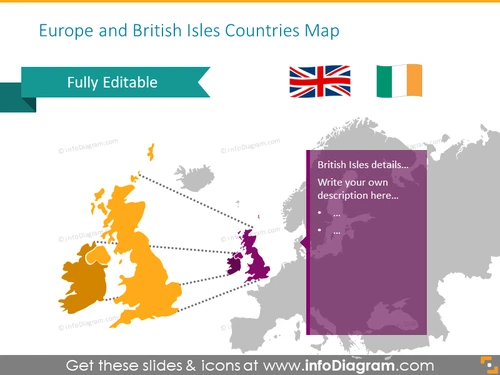
- Outline maps of Europe, Great Britain, and Ireland
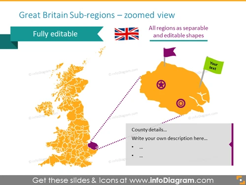
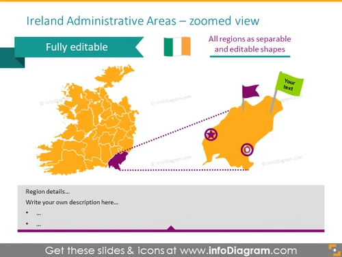
- UK and Ireland maps with administrative territories (counties) and main city location pins
- British Union Jack and Irish flag
- Geographic location placeholders, icons, and hand-drawn arrows to present specific places on a map e.g. of a POI or regional meeting plan
- Country macro-economy symbols & data: population, density, GDP, capital, transport, production, distribution
- Fully editable maps, vector icons, arrows
Why use the British Isles map collection?
British Isles maps collection will help you to explain your thoughts and plans with visual reference points. Maps are easily editable and customizable and they can be embedded into presentations or any other documents. You can present your ideas and plans for upcoming meetings, highlight relevant areas or make labels. Maps are great for expressing visually complex logistical plans. British Isles collection will help you to illustrate flights, and train connections, and record the different types of meetings and destinations.
How to use British Isles Map UK Ireland with Counties?
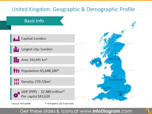
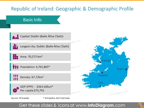
A few ideas where you can apply those illustrations:- Illustrate geographic and demographic country profile: Population, Density, Area, GDP, Largest city, Capital.
- Present a strategy for sales trips within your company or explain your overall sales strategy.
- Highlight relevant areas on the map, which will support the discussed topics.
- Illustrate flights and train connections, and record the different types of meetings and destinations.
Content:
British territories list presented in the British Isles maps diagram:
- The United Kingdom with largest cities Belfast, Edinburg, Cardiff, London;
- Ireland with largest cities Galway, Limerick, Dublin, Cork, and administrative divisions:
- County of Antrim
- County of Armagh
- County of Down
- County of Fermanagh
- County of Londonderry
- County of Tyrone
- England with countries:
- East of England
- East Midlands
- London
- North East
- North West
- South East
- South West
- West Midlands
- Yorkshire and the Humber
- Scotland with countries:
- Caithness
- Sutherland
- Ross and Cromarty
- Inverness-shire
- Nairnshire
- Moray
- Banffshire
- Aberdeenshire
- Kincardineshire
- Angus
- Perthshire
- Argyll
- Bute
- Ayrshire
- Renfrewshire
- Dunbartonshire
- Stirlingshire
- Clackmannanshire
- Kinross-shire
- Fife
- East Lothian
- Midlothian
- West Lothian
- Lanarkshire
- Peeblesshire
- Selkirkshire
- Berwickshire
- Roxburghshire
- Dumfriesshire
- Kirkcudbrightshire
- Wigtownshire
- Zetland
- Orkney
- Northern Ireland and administrative divisions:
- Antrim
- Armagh
- Down
- Fermanagh
- Londonderry
- Tyrone
- Wales and administrative divisions:
- Blaenau Gwent
- Bridgend
- Caerphilly
- Cardiff
- Carmarthenshire
- Ceredigion
- Conwy
- Denbighshire
- Flintshire
- Gwynedd
- Isle of Anglesey
- Merthyr Tydfil
- Monmouthshire
- Neath Port Talbot
- Newport
- Pembrokeshire
- Powys
- Rhondda Cynon Taf
- Swansea
- Torfaen
- Vale of Glamorgan
- Wrexham
Icons for showing localization and logistics on maps:
Further information sources on countries data
Acronyms used
- GDP – Gross Domestic Product
- PPP - Purchasing Power Parity
- sq mi – square mile
- km2 – square kilometer
Editable elements
Fully editable vector shapes by using built-in PowerPoint tools, including- editing texts
- editing maps (color of the fill and outline, style - gradient, with outline, shadow, reflection)
- arrows and icon pictograms: changing fill color, size, style (gradient fill, outline, shadow, reflection)
- all elements are transparent (charts, maps, flags, arrows), you can put them behind or above your content
Author
- InfoDiagram contributor & Prezentio.com designers
- Contact: infoDiagram
Slides included in this PowerPoint Presentation:
- British isles zoomed map
- Great Britain Sub-regions Map - infoDiagram
- Ireland Administrative Areas Map - infoDiagram
- United Kingdom Demographic & Geographic Profile - infoDiagram
- Ireland Demographic & Geographic Profile - infoDiagram
- British Isles Country Descriptions Template - infoDiagram
- Meeting Plan Over English Counties - infoDiagram
- English Ceremonial Counties Map - infoDiagram
- Influence UK regions map illustrated with transparent circles
- Ireland map showed with transparent circles with data
- UK map illustrated with places pins
- Example of the UK and Ireland maps with hand-drawn routes
- UK transport map with flights and train routes
- Supply chain Ireland map showing production and distribution
- Administrative subdivision United Kingdom map
- United Kingdom map presenting administrative division regions
- English ceremonial counties with description
- Example of the Welsh council areas with description
- Scottish council areas with text description
- Northern Ireland district map illustrated with pins
- United Kingdom map on dark background
- Ireland administrative division regions and cities map
- Irish administrative division map with text description
- Location pins and flags icons set
- Icons demographic signs
- Example of the meeting symbols set
- Transport icons set
- Example of the buildings icons set
- Distribution and retail icons
- Direction and distance arrows illustrated with handdrawn and ink style
- British Isles Map UK Ireland with Counties (PPT editable)
How To Edit
How to edit text & colors

How to expand / shorten diagram

How to Replace Icons in infoDiagram PPT
