Financial Decks
Visualize your results with ease
Germany federal states map
from deck
Western Europe Map with Administrative Territories (Germany, France PPT editable Maps)
Info
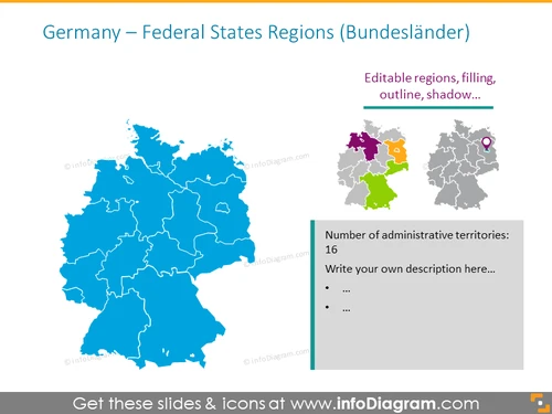
Germany – Federal States Regions (Bundesländer)
Slide Content
The slide presents a map of Germany highlighting its federal states, known as "Bundesländer." It indicates that the regions on the map are editable, including features such as filling, outline, and shadow. Additionally, a small sidebar provides space to enumerate the number of administrative territories, which is indicated as 16, and to include a custom description that supports the map’s data.
Graphical Look
- A large, detailed map of Germany occupies the central and left part of the slide, with the federal states outlined and filled in blue.
- To the right of the main map, there's a smaller map showing a highlighted region on the map in four distinct colors with a purple location pin icon.
- A sidebar with a light yellow background to the right side provides text space alongside a smaller grey outline of Germany.
- A horizontal line above the sidebar text emphasizes the editable nature of the regions on the maps.
- Icons and text placeholders within the sidebar suggest the possibility to add custom descriptions about the administrative territories.
The slide has a minimal and professional look, leveraging shades of blue and grey, contrasting with the yellow sidebar. It is well-organized with clear demarcation between the visual element (map) and the informational sidebar.
Use Cases
- To provide a geographical overview of Germany's federal structure during educational or training sessions.
- In business presentations to highlight specific regions where the company operates or has market interests.
- As part of a demographic analysis or marketing strategy to focus on regional differences or targeted campaigns.
- During political or economic discussions to identify and discuss the characteristics of different Bundesländer.


