Financial Decks
Visualize your results with ease
United Kingdom and Europe Map
from deck
Brexit Impact Presentation & UK-EU economy facts (PPT Template)
Info
United Kingdom & Europe Map
Slide Content
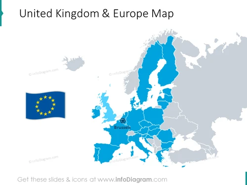
The PowerPoint slide presents a stylized map showing the relationship between the United Kingdom and Europe. A separate floating graphic of the European Union flag suggests a connection or distinction between the UK and the rest of Europe. The map could be referencing the geopolitical landscape post-Brexit, as the UK is colored differently from the EU member nations. A marker over Brussels implies a specific point of focus or importance, possibly denoting the administrative center of the European Union.
Graphical Look
- A two-toned geographical map predominates the slide, with countries presumably in the European Union filled in a darker blue shade.
- The United Kingdom is depicted in a lighter shade, distinct from the rest of the map.
- A realistic, wavy European Union flag graphic is placed to the left of the map.
- A circular icon with a star denoting Brussels is overlaying the map at the city's approximate geographical location.
- The countries on the map are outlined in a darker grey, providing clear separation and definition.
The slide has a clean and minimalistic design, with a selective use of colors to emphasize different regions. The graphical elements such as the EU flag and the Brussels icon add contextual information to the geographical representation.
Use Cases
- To discuss the political or economic landscape between the UK and the EU in a post-Brexit scenario.
- To highlight trade relations or regulatory differences in business presentations involving European markets.
- For educational purposes to illustrate the geographical borders and political entities within Europe.
- As a backdrop in discussions about international relations or European travel and logistics planning.


