Financial Decks
Visualize your results with ease
Map African Route Arrows Algeria Namibia South Africa PPTX
from deck
Maps of African Countries (PPT icons Population, GDP, transport)
Info
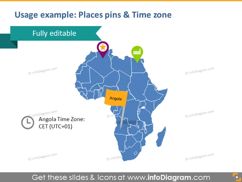
Usage example: Places pins & Time zone
Slide Content
The slide presents how geographical locations and time zones can be visually represented using pins on a map. It includes an outline map of Africa with highlighted countries and a specific focus on Angola, which is marked with a pinpoint and labeled. Beside Angola, there is a note indicating that the country is in the Central European Time Zone (UTC+01).
Graphical Look
- A large, blue-colored outline map of Africa occupies the central portion of the slide.
- Three pin icons of different colors and shapes are placed on the map, representing various locations.
- A bright yellow rectangular callout points to Angola, with the country's name clearly labeled.
- A clock icon accompanied by the text "Angola Time Zone: CET (UTC+01)" is positioned in the bottom left corner.
- A wide, dark teal ribbon banner overlaps the top part of the Africa map slightly, containing the text "Fully editable" in white uppercase letters.
The slide features a clean and professional design, with a good contrast between the map and the infographic elements. The use of different colors for pins and callouts helps to draw attention to specific information on the map.
Use Cases
- To present the geographic expansion of a company or branches across the African continent.
- To illustrate the time zone differences affecting international business operations or project coordination.
- To highlight the locations of key partners or clients within Africa during a business meeting or proposal.
- To visualize market research data or sales figures tied to specific locations within the context of a continent-wide strategy discussion.


