Financial Decks
Visualize your results with ease
Metropolitan France administrative division regions
from deck
Western Europe Map with Administrative Territories (Germany, France PPT editable Maps)
Info
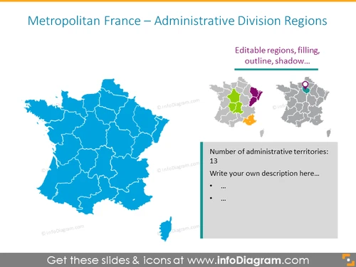
Metropolitan France – Administrative Division Regions
Slide Content
The slide is about the administrative division regions of Metropolitan France. It showcases the editable features of the regions such as filling, outline, and shadow options. The map is divided into regions, with a focus slide showing the highlighted region feature. A side panel mentions the number of administrative territories, which is 13, and prompts the user to add their own description.
Graphical Look
- A large map of France fills most of the slide, with regions outlined and colored in blue.
- A smaller map to the right shows a single highlighted region in various colors, emphasizing the editable feature of individual regions.
- A circular icon with a location pin is placed over the highlighted region on the smaller map, indicating an area of interest.
- A vertical text box next to the small map, which includes a heading and bullet points for additional information.
- The slide has a clean and modern look with a white background, accentuated by the colorful maps and text box.
The slide has a professional and crisp appearance, utilizing a blue and gray color palette. The contrast between the large blue map and the smaller multicolored map section draws attention to the editable region feature.
Use Cases
- To present regional sales or performance data in a business meeting, highlighting specific areas of interest.
- To use in an educational setting for geography or social studies lessons, demonstrating France's administrative divisions.
- For a strategic planning session involving regional analysis, such as market expansion or resource allocation.
- To illustrate demographic or electoral information in a political or social context, focusing on certain administrative territories.


